January 31, 2021
Location, Standard Time & Borders of India
Contents
India pakistan china bangladesh border
- India is the 7th largest country in the world with 3287263 sq km which is 2.4% of world area.
Borders of India Pakistan china Bangladesh Indian standard time
Largest Countries in the World by Area
| Rank | Country | Capital City |
|---|---|---|
| 1 | Russia | Moscow |
| 2 | Canada | Ottawa |
| 3 | United States of America | Washington DC |
| 4 | China | Beijing |
| 5 | Brazil | Brasilia |
| 6 | Australia | Canberra |
| 7 | India | New Delhi |
| 8 | Argentina | Buenos Aires |
| 9 | Kazakhstan | Nur-Sultan |
| 10 | Algeria | Algiers |

India pakistan china bangladesh border
Location of India
North to South
- Latitude 370 6′ north to 80 4′ north (main land) and 60 45′ north Indira Point or Pygmalion point (Indian Island).
- Indira Col (J&K) in North and Kanyakumari (Tamilnadu) in South.
- North to south distance of Indian main land is 3214 Km.
West to East
- Longitude – 680 7′ East to 970 25′ East
- Ghaur Moti in Gujrat to Kibithu in Arunachal Pradesh.
- West to east distance of Indian main land is 2933 Km.
Borders of India
Highest Point of India
- Kangchenjunga 8,586 m (Sikkim)
>>>>>>>>>
Lowest Point in India
- Kuttanad -2.2 m (Kerala)
>>>>>>>
India pakistan china bangladesh border
Indian Standard Time – IST
- Indian Standard Time is calculated on the basis of 82o 30′ or 82.5o East longitude.
- 82o 30′ East Longitude going through west of the town of Mirzapur, near Allahabad.
- Indian Standard Time is 5 hours 30 min ahead of Greenwich Mean Time.
- 82o 30′ East Longitude is going through 5 state – UP, MP, Chhattisgarh, Orissa, AP.
- Time difference between eastern most and western most point of India is 1 hour 56 min.
- National Physical Laboratory India (NPLI) is the Time Keeper of the Country.
- It works under Council of Scientific & Industrial Research (CSIR).
- Before independence there were 2 standard time, Calcutta Time and Bombay Time.
- It continued until 1948 and 1955, respectively.
- Assam, tea gardens follow a separate time zone, known as the Chaibagaan or Bagan time, which is 1 hour ahead of IST.
- It allowed by Plantations Labour Act, 1951.
>>>>>>>>>
India pakistan china bangladesh border
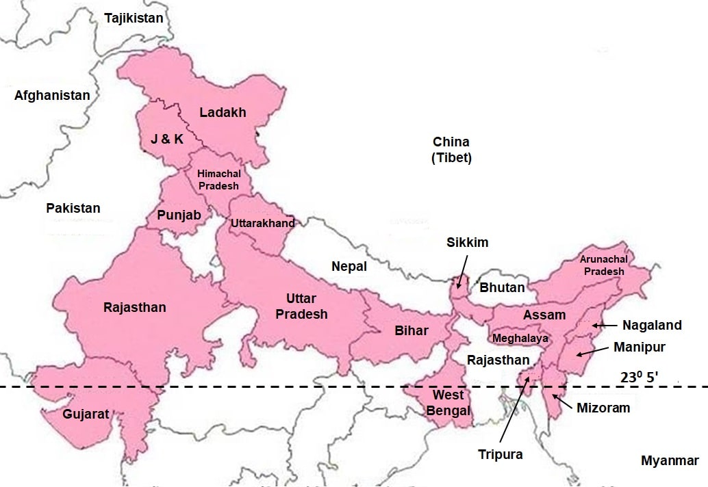
Tropic of Cancer (230 5′ N latitude)
- Its passes through 8 states – Gujarat, Rajasthan, MP, Chhattisgarh, Jharkhand, WB, Tripura, Mizoram.
>>>>>>>>>
India pakistan china bangladesh border
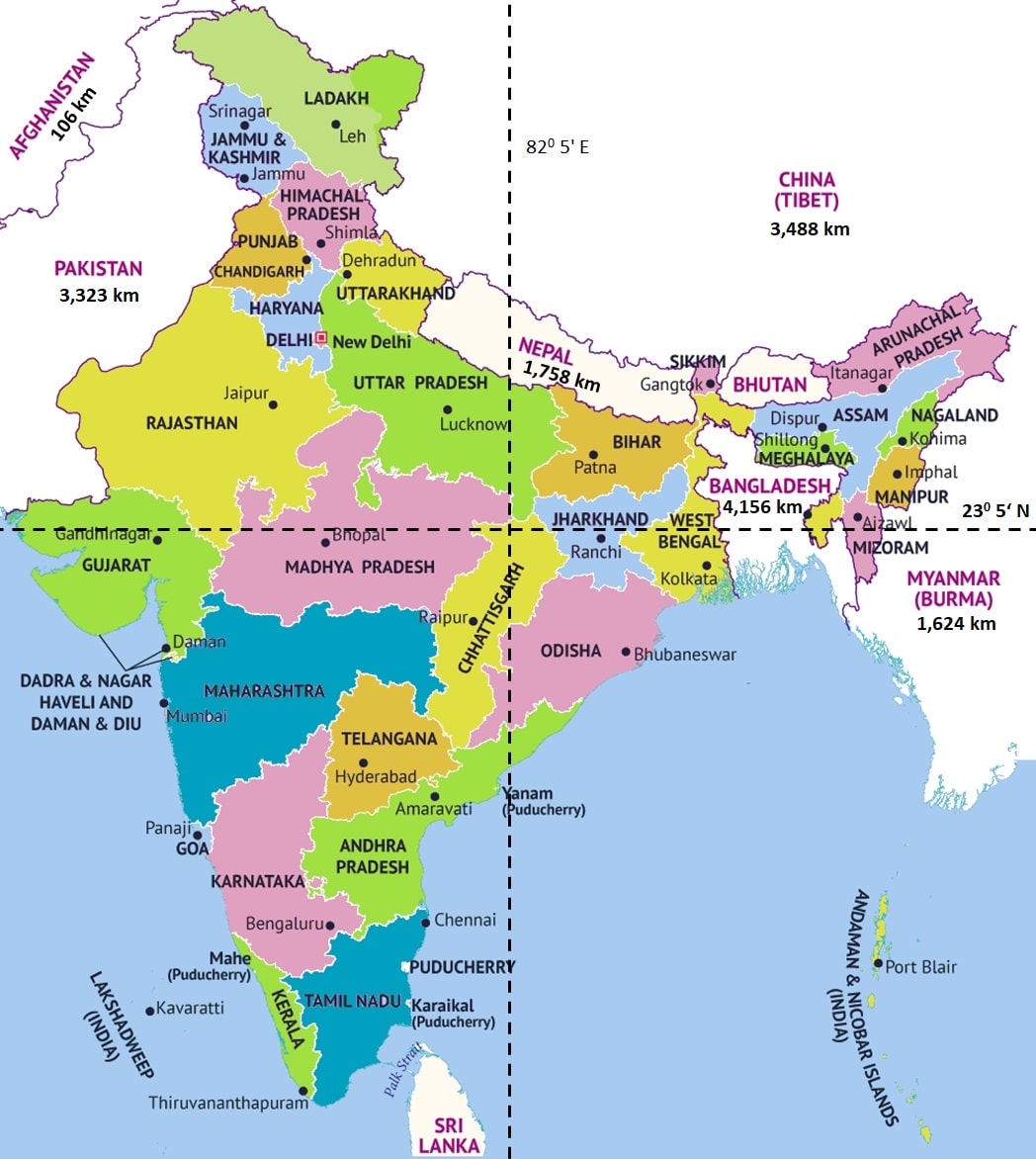
Neighbour Countries & Borders of India
- India has 15106.7 km of land border running through 92 districts in 18 States & UTs.
- India shares land borders with 7 countries
- Bangladesh – 4,156 km
- China – 3,488 km
- Pakistan – 3,323 km
- Nepal – 1,758 km
- Myanmar – 1,624 km
- Bhutan – 699 km
- Afghanistan – 106 km
- Coastline of India is 7516.6 Km (6100 km of mainland coastline + coastline of 1417 Indian islands) touching 13 States and UTs.
- Maritime borders of India are recognized by the UN Convention on the Law of the Sea.
- Territorial water can be divided into
- Contiguous zones – 12-nautical-mile
- Exclusive economic zones – 200-nautical-mile
- India has a more than 7000 km maritime border shared with 7 countries
- Bangladesh – New Moore Island
- Indonesia – Indira Point
- Myanmar – Coco Islands
- Pakistan – Sir Creek
- Thailand – Similan Islands
- Sri Lanka – Katchatheevu
- Maldives – Maliku Kandu
>>>>>>
>>>>>>
Land Borders of India
India Bangladesh Border
- India Bangladesh Border is the 5th longest land border in the world.
- This boundary has been determined under the Radcliffe Award.
- This border is guarded by Border Security Force (BSF).
- India Bangladesh Border state wise
- West Bengal – 2,217 km
- Tripura – 856 km
- Meghalaya – 443 km
- Assam – 262 km
- Mizoram – 180 km
- India & Bangladesh has Bus and Railway connection and Border Haats.
- India–Bangladesh enclaves, also known as the chitmahals.
- Tin Bigha Corridor is a strip of land belonging to India was leased to Bangladesh to access its Dahagram–Angarpota enclave in Sept 2011.
- Dahala Khagrabari was the world’s only third–order enclave.
- It was ceded to Bangladesh through 100th amendment act in Constitution of India in 2015.
Borders of India
India China Border
- India China border name is Mc Mahon Line.
- This boundary agreement was signed at Shimla accord in 1913-14.
- India China border is guarded by Indo-Tibetan Border Police (ITBP).
- Boundary as per states
- J&K and Ladakh – 1597 km
- Arunachal – 1126 km
- Uttarakhand – 463 km
- Himachal – 345 km
- Sikkim – 220 km
- India, China and Myanmar form the tri-point borders at the Diphu mountain pass, nearby Walong, Arunachal Pradesh.
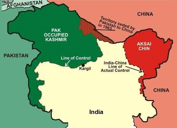
- Line of Actual Control (LAC) separates Indian-controlled territory from Chinese-controlled territory in the Ladakh region.
- It was formed after the 1962 war.
>>>>>>>>
India Pakistan Border
- India Pakistan border is the result of partition of the country in 1947 under the Radcliffe award.
- India Pakistan border name is Radcliffe line.
- This border is guarded by Border Security Force (BSF).
- India Pakistan border state wise
- J&K & Ladakh – 1222 km
- Rajasthan – 1170 km
- Gujrat – 506 km
- Punjab – 425 km
- Line of Control (LoC) is the military control line between the India and Pakistan controlled part of Jammu and Kashmir.
- LoC is not a legally recognized international boundary.
- It is originally known as the Cease-fire Line.
- It was redesignated as the “Line of Control” after the Simla Agreement, signed on 3rd July 1972.
- The northernmost point of the Line of Control is known as NJ9842.
- India Pakistan border continues from the southernmost point on the LoC.
- Sir Creek is a 96 km long disputed maritime boundary line.
- It is a tidal estuary of the Indus River located between Gujarat of India and Sindh of Pakistan.
Borders of India
India Nepal Border
- India Nepal Border, is an open international border.
- This border was established after the treaty of Sugauli in 1816 between Nepal and British India.
- India-Nepal Treaty of Peace and Friendship was signed at Kathmandu on 31 July 1950, which allows free movement of people and goods between the two nations.
- This border is guarded by Sashastra Seema Bal (SSB).
- India Nepal border as per states
- UP – 651 km
- Bihar – 601 km
- Uttarakhand – 303 km
- Sikkim – 98 km
- WB – 96 km
Borders of India
India Myanmar Border
- India Myanmar border was decided by the treaty of Yandabo in 1826.
- This border is guarded by Assam Rifles.
- Assam Rifles is the oldest paramilitary force of India.
- India Myanmar border as per states
- Arunachal – 520 km
- Mizoram – 510 km
- Manipur – 398 km
- Nagaland – 215 km
- India Myanmar border has a Free Movement Regime.
- It allows tribes living along the border to travel 16 km across either side of the border without visa.
- India–Myanmar–Thailand Trilateral highway also known as East-West Economic Corridor is the AH1 of Asian Highway Network.
- It will connect Moreh (Manipur), India with Mae Sot, Thailand via Myanmar.
Borders of India
India Bhutan Border
- Treaty of Peace between Britain and Bhutan demarcated the India Bhutan border in 1865, following the Bhutan War.
- The boundary was refined in the 1973-1984 period.
- This border is guarded by Sashastra Seema Bal (SSB).
- India Bhutan border as per states
- Assam – 267 km
- Arunachal – 217 km
- WB – 183 km
- Sikkim – 32 km
- The India Bhutan border is the only land access to Bhutan, as the border with China is completely closed.
- The single entry point for foreign nationals is between the towns of Jaigaon, (WB) India and Phuntsholing, Bhutan.
>>>>>>>>>
India Afghanistan Border
- It is called Durand line.
- In 1893, it was established between British India and Emirate of Afghanistan as international border.
- India Afghanistan border is 106 km long and in the region of PoK.
Borders of India
>>>>>>>>>
Other Facts about Borders of India
- Longest international border of States & UTs
- West Bengal – 2509.7 Km
- Arunachal – 1,817 km
- Rajasthan – 1170 km
- Nagaland has the smallest international border of 215 km.
- 3 states and 1 UT have international boundary with 3 countries
- Sikkim – China, Nepal, Bhutan
- West Bengal – Bhutan, Nepal, Bangladesh
- Arunachal Pradesh – China, Bhutan, Myanmar
- Ladakh – Pakistan, China, Afghanistan
Borders of India