Contents
>>>>>
- Indo-Gangetic plain lies to the south of the Shissalik mountain separated by the Himalayan Front Fault (HFF).
- Indo-Gangetic plain also known as Northern plains of India or Great plain of India.
- It is a transitional zone between the Himalayas of the north and Peninsular India
- Indo-Gangetic-Brahmaputra Plain is the largest alluvial tract of the world.
- It stretches for about 3,200 km from the mouth of the Indus to the mouth of the Ganga.
- Indian sector of the plain accounts for 2,400 km.
- The western boarder is marked by Sulaiman and Kirthar ranges.
- On the eastern side, the plains are bordered by Purvanchal hills.
- Average elevation of the Northern plains of India is about 200 m above mean sea level.
>>>>>>>>
>>>>>>>>
Formation of the Indo-Gangetic plain
- The rivers which were previously flowing into Tethys sea deposited huge amount of sediments in the Tethys Geosyncline.
- Himalayas are formed out of these sediments which were uplifted, folded and compressed due to northern movement of Indian Plate.
- Northern movement of Indian Plate also created a trough to the south of Himalayas.
>>>>>>
Depositional Activity
- During the initial stages of upliftment of sediments, the already existing rivers changed their course several times
- Rivers also rejuvenated each time for that reason.
- Head-ward erosion and vertical erosion of the river valley contributed huge amount of sediments.
- These sediments were deposited in the depression between peninsular India and the convergent boundary.
>>>>>>
Sponsored


New Rivers & more Alluvium
- The raising of Himalayas and subsequent formation of glaciers gave rise to many new rivers.
- These rivers along with glacial erosion supplied more alluvium.
- Those alluvium intensified the filling of the depression.
- With the accumulation of more and more sediments, the Tethys sea started receding.
- With passage of the time, the depression was completely filled with alluvium, gravel, rock debris.
- The Tethys completely disappeared leaving behind a monotonous aggradation plain.
- Upper peninsula rivers have also contributed to the formation of plains, but to a very small extent.
- Since few million years, depositional work of three major river systems, The Indus, the Ganga and the Brahmaputra have become predominant.
>>>>>
Division as per Soil Types
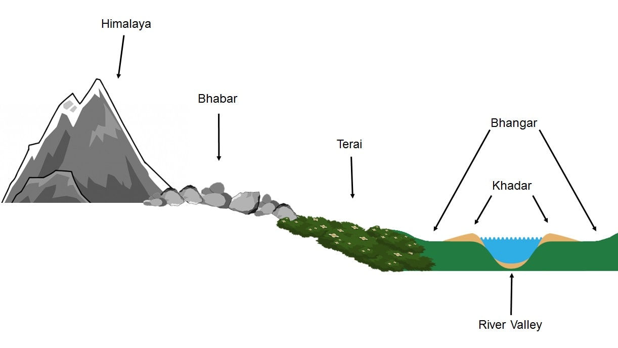
Bhabar Soil Region
- The Bhabar soil region is a narrow, porous, northern most stretch of Indo-Gangetic plain.
- It is about 8-16 km wide along the foothills of the Shiwaliks.
- Bhabar show a remarkable continuity from the Indus to the Tista.
- Porosity of bhabar is unique feature, due to deposition of huge number of pebbles and rocks.
- The streams disappear once they reach the bhabar region because of this porosity.
- The area is not suitable for agriculture and only big trees with large roots thrive in this belt.
Terai Region
- Terai region is an ill-drained, damp (marshy) and thickly forested narrow tract.
- It is located to the south of Bhabar running parallel to it.
- Terai region is about 15-30 km wide.
- The underground streams of the Bhabar belt re-emerge in the Terai Region.
- Terai soils are rich in nitrogen and organic matter.
- This soil is deficient in phosphate.
- Terai region is covered with thickly forest, provides shelter to a variety of wild life.
- Terai region is wider in the eastern part because of higher amount of rainfall.
- Most of the Terai land, in Punjab, Uttar Pradesh and Uttarakhand, has been turned into agricultural land.
- Terai region land gives good crops of sugarcane, rice and wheat.
Dooars Region
- Terai region of east side of Teesta River is called Dooars.
- It stretches over about 350 km up to Dhansiri River in Assam.
- Dooars means ‘doors’ in different local languages.
- This region is gateways between Bhutan and plains in India.
- Economy of Dooars region is based on Tea, Tourism and Timber.
- Many protected forests are located in this area.
Bhangar Region
- The Bhangar is the older alluvium along the river beds of Indo-Gangetic plain.
- It forms terraces higher than the flood plain.
- Bhangar contains concretions and nodules of impure calcium carbonate known as ‘Kankar’.
- It contains fossils of animals like rhinoceros, hippopotamus, elephants, etc.
- The Barind plains in the delta region of Bengal is a part of Bhangar region.
- The Bhur formations in the middle Ganga and Yamuna doab are regional variations of Bhangar.
Bhur
- Bhur denotes an elevated piece of land situated along the banks of the Ganga river
- It developed mainly in the upper Ganga-Yamuna Doab.
- This has been formed due to accumulation of wind–blown sands during the hot dry months of the year
Sponsored
Khadar Region
- The Khadar is composed of newer alluvium and forms the flood plains along the river banks.
- A new layer of alluvium is deposited by river flood almost every year.
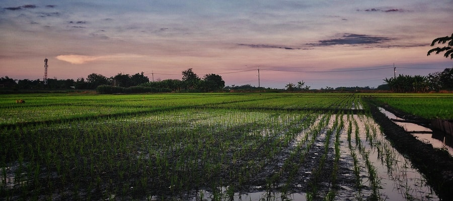
- The Khadar is the most fertile soils of Indo-Gangetic plain.
- In Punjab, the Khadar rich flood plains are locally known as Betlands or Bets.
Reh or Kollar
- Reh or Kollar comprises saline efflorescence of drier areas in Haryana.
- Reh areas have spread in recent times with increase in irrigation.
- The capillary action brings the underground salts to the surface.
>>>>>>>>

>>>>>>>>
West to East Division of Indo-Gangetic Plain
- Sindh Plain
- Rajasthan Plain
- Punjab Plain
- Gangetic Plains
- Upper Gangetic Plain
- Middle Gangetic Plain
- Lower Gangetic Plain
- Ganga – Brahmaputra Delta
- Brahmaputra Plain
Sindh Plain
- Sindh Plain is mainly formed of Bhangar Plains by Indus and its tributaries.
- Dhors is long narrow depressions which are the remnants of the course of former rivers.
- Dhand is alkaline lakes on some dhors.
Rajasthan Plain
- Rajasthan plain occupied by Thar or the Great Indian Desert.
- This plain is an wave like plain whose average elevation is about 325 m.
- The desert region is called Marusthali and forms a greater part of the Marwar plain.
- Geologically it is a part of the Peninsular Plateau.
- It has a few outcrops of gneisses, schists and granites.
- Rajasthan plain is only at the surface that it looks like an aggradation plain.
- In general, the eastern part of the Marusthali is rocky while its western part is covered by shifting sand dunes
- Eastern part of the Thar Desert up to the Aravali Range is a semi-arid plain known as Rajasthan Bagar.
- It is drained by a number of short seasonal streams originating from the Aravali.
- Luni is an important seasonal stream
- The tract north of the Luni is known as thali or sandy plain.
- North of the Luni, there is inland drainage having several saline lakes.
- Sambhar, Didwana, Degana, Kuchaman are some of the important lakes in the Rajasthan plain.
- The largest is the Sambhar lake near Jaipur.
>>>>>>>>
Sponsored
Punjab-Haryana Plain
- Punjab-Haryana plain is formed by five important rivers of Indus system.
- The plain is primarily made up of ‘doabs’ – the land between two rivers.
- Punjab means “The Land of Five Rivers” referring to the following rivers: the Jhelum, Chenab, Ravi, Sutlej, and Beas.
- The eastern boundary of Punjab Haryana plain is marked by subsurface Delhi-Aravali ridge.
- Northern part of this plain near Shiwalik hills has been intensively eroded by numerous streams called Chos landform.
- The only river between the Yamuna and the Satluj is the Ghaggar.
- The Ghaggar is considered to be the present day Successor of the legendary Saraswati River.
- The Punjab-Haryana Plains may be divided into
- Bari Doab between the Beas and Ravi
- Bist Doab between the Beas and Satluj
- Malwa Plain the central part of the region
- Hariyana–Bhiwani Bagar in the southern and south-eastern parts of the region.
Gangetic Plains
- Ganga PIain lie between the Yamuna catchment in the west to the Bangladesh border in the east.
- The Ganga along with its large number of tributaries originating in the Himalayans
- Those rives have brought large quantities of alluvium from the mountains and deposited it here to build this extensive plain.
- The peninsular rivers such as Chambal, Betwa, Ken, Son, etc. joining the Ganga river system.
- General slope of the entire plain is to the east and south east.
- Rivers flow sluggishly in the lower sections of Ganges.
- As a result the area is marked by local prominences such as levees, bluffs, oxbow lakes, marshes, ravines, etc.
- Almost all the rivers keep on shifting their courses making this area prone to frequent floods.
- The Kosi river is very notorious in this respect. It has long been called the ‘Sorrow of Bihar’.
Upper Gangetic Plain
- It includes the Ganga–Yatnuna doab, Rohilkhand Division and parts of the Agra Division.
- The catchment area of the Yamuna river makes its western boundary
- In addition to Ganga and the Yamuna, it is traversed by the Kali and Sharda rivers.
- A unique feature of the Upper Gangetic Plain is the presence of Bhur
Middle Gangetic Plain
- It includes central and eastern Uttar Pradesh, and the Bihar Plains up to Muzaffarpur and Patna.
- It has thick alluvial deposits with less Kankar formation.
Lower Gangetic Plain
- Lower Gangetic Plain extends from Patna in the west, the foot of Darjeeling Himalaya in the north to the Bay of Bengal in the south.
- It is bordered by Assam and Bangladesh in the cast and the Chotanagpur Plateau in the west.
- In the lower part of the Lower Ganga Plain is Sundarban delta.
- The plain has a monotonous surface.
- The Lower Gangetic Plain is the divider between between Rajmahal Hills of Peninsular India and the Meghalaya Plateau
- It formed by subsequent sedimentation by the Ganga and the Brahmaputra rivers.
Rahr Plain
- It lying to the east of the Chotanagpur Plateau, it is a part of the Lower Gangetic Plains.
- Drained by the Damodar and Subarnarekha river.
- It covered by the lateritic-alluvium soils
- Soil erosion is the main problem of the Rahr plain region.
- Rice, maize and pulses are the main crops here.
>>>>>>>>
Sponsored
>>>>>>>>
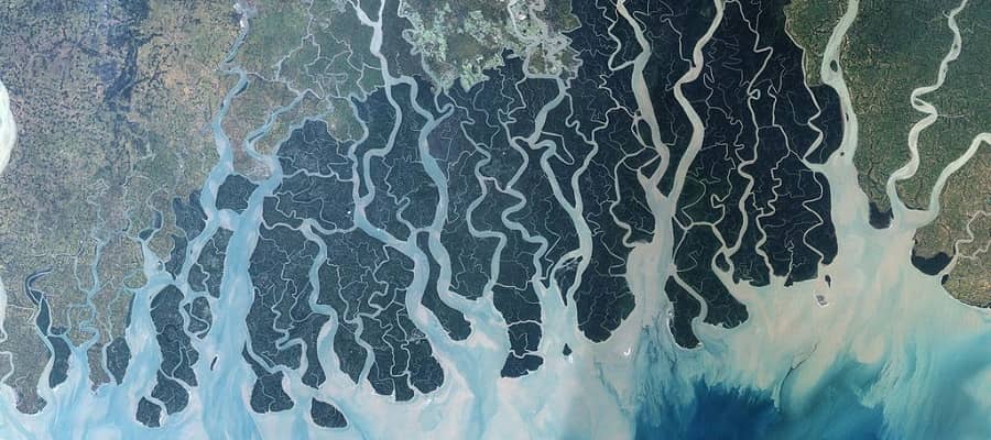
Ganga-Brahmaputra Delta or Sundarban Delta
- Ganga-Brahmaputra Delta or Ganges delta is the largest delta in the world.
- The Ganga river divides itself into several channels in the delta area.
- Ganges delta is studded with a large number of estuaries, mud flats, mangrove swamps, sandbanks, islands and forelands.
- Large part of the coastal delta is a part of Sundarban delta and covered by tidal forests.
- Sundarban is the largest mangrove swamp in the world.
- Sundarhan gets its name from the Sundari tree (Heritiera fomes) which grows well in marshland.
- Mangrove forest covers an area of about 10,000 km2
- In West Bengal, they extend over 4,260 km2 across South 24 and North 24 Pargana district.
- East India Company appointed William Dampier and Hodges to survey and identify the boundaries of the Sundarbans forest in 1764.
- Sundarban enlisted as UNESCO World Heritage Sites in 1987 for it’s biodiversity.
- In 2019, it has been designated as a Ramsar site.
- It is considered as a World Network of Biosphere Reserve from 2001.
Brahmaputra Plain
- Brahmaputra plain is also known as Assam Valley.
- Most of the Brahmaputra valley is situated in Assam.
- Its western boundary is formed by the Indo-Bangladesh border as well as the boundary of the lower Ganga Plain.
- Its eastern boundary is formed by Purvanchal hills.
- Tributaries of the Brahmaputra river coming from the north form a number of alluvial fans.
- Tributaries branch out in many channels giving birth to river meandering leading to formation of bill and ox-bow lakes.
- There are large marshy tracts in this area.
- Manas, Kaziranga, Orang National Parks are located in this area.
- The alluvial fans formed by the coarse alluvial debris have led to the formation of terai or semi-terai conditions with dense forest
- Brahmaputra plains have numerous islands.
- Majuli (area 930 sq km) is the largest river island of the world and country’s first river island district.
Significance of the Northern Plains of India
- Northern plains of india is one fourth of the land of the country, hosts half of the Indian population.
- Fertile alluvial soils, flat surface, slow moving perennial rivers and favorable climate facilitate intense agricultural activity.
- Use of irrigation has made Punjab, Haryana and western part of Uttar Pradesh the granary of India (Prairies- granaries of the world).
- The entire Indo-Gangetic plain except the Thar Desert, has a close network of roads and railways.
- Indo-Gangetic plain has led to large scale industrialization and urbanization.
- There are many religious places along the banks of the sacred rivers like the Ganga and the Yamuna.
- Those are very dear to Hindus.
- Here flourished the religions of Budha and Mahavira and movements of Bhakti and Sufism
>>>>>